What to see in Municipality Fuencaliente De La Palma

Municipality Fuencaliente De La Palma is an administrative unit in Province Santa Cruz de Tenerife.

Volcano de Teneguia
Category: Volcano
Location: municipality Fuencaliente De La Palma »
Latitude: 28.47378420
Longtitude: -17.85119530
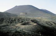
Volcano de Teneguia is located at southern part of island of La Palma in municipality of Fuencaliente De La Palma. It is  the younger volcano of all Canary Islands and Spain - the last eruption on La Palma (in 1971) was Teneguia volcano, and continued for 24 days. The landscape looks like from ...
Volcanologic Information Centre
Category: Volcano
Location: municipality Fuencaliente De La Palma »
Volcanologic Information Centre at the San Antonio Volcano is situated in Fuencaliente De La Palma. There visitors can get details and facts (tables, graphics, aerial photographs) of the island and active seismographs information about volcanism on La Palma and especially the San Antonio Volcano....
San Antonio volcano
Category: Volcano
Location: municipality Fuencaliente De La Palma »
Latitude: 28.48385600
Longtitude: -17.85018680
San Antonio volcano is situated in immediate vicinity of the In immediate vicinity of the Volcanologic Information Centre in Fuencaliente De La Palma.It was formed from an eruption in the year 1677. On the occasion of a stroll along the edge of its crater, the visitors can gain an idea about the...
Cadiz Almeria Granada Cordoba Huelva Jaen Malaga Seville Huesca Zaragoza Teruel Madrid Alava Guipuzcoa Biscay Las Palmas Santa Cruz De Tenerife Formentera Eivissa Majorca Minorca Cantabria Zamora Valladolid Soria Segovia Salamanca Palencia Leon Burgos Avila Toledo Guadalajara Cuenca Ciudad Real Albacete Tarragona Lleida Girona Barcelona Badajoz Caceres Navarre Pontevedra Ourense Lugo A Coruna La Rioja Murcia Asturias Valencia Castellon Alicante