 Category: Parks & Gardens
Location: municipality Haria »
Latitude: 29.15724900
Longtitude: -13.43203600
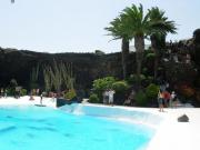
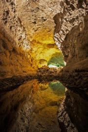
Jameos del Agua is located on the north-western coastline of Lanzarote island, east of town of Haria. They are formed when the ceiling of a volcanic tunnel collapses, leaving a deep pit. The sides of the pit reveal an intricate network of volcanic bubbles and passages. The Jameos del Agua were...
 English (en)
 Deutsch (de)
 Русский (ru)
 Français (fr)
 Español (es)
 Български (bg)
 Português (pt)
 日本の (jp)
 한국의 (kr)
 中國的 (cn)
 Nederlands (nl)
 Italiano (it)