What to see in Province Santa Cruz de Tenerife

Province Santa Cruz de Tenerife is an administrative unit in Autonomous community Canary Islands.

Belmaco Cave
Category: Cave
Location: municipality Villa De Mazo »
Latitude: 28.57794790
Longtitude: -17.77684450
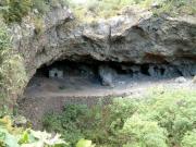
Belmaco Cave is located in municipality of Villa De Mazo, Island of La Palma (Canaries), north of Malpaíses and south of Lomo Oscuro (7km). The region was inhabited in the past by the Guanche and it was the home of the kings of Mazo. The life a culture of the Canarian natives is explained in and a...
Volcano de Teneguia
Category: Volcano
Location: municipality Fuencaliente De La Palma »
Latitude: 28.47378420
Longtitude: -17.85119530
Volcano de Teneguia is located at southern part of island of La Palma in municipality of Fuencaliente De La Palma. It is  the younger volcano of all Canary Islands and Spain - the last eruption on La Palma (in 1971) was Teneguia volcano, and continued for 24 days. The landscape looks like from ...
volcano Mount Teide
Category: Volcano
Location: municipality Santiago del Teide »
volcano Mount Teide is situated of Island of Tenerife. The entire island has volcanic origins but it is dominated by the 3718 meters high volcano Mount Teide with its mighty crater. The Teide is not only the highest mountain of all Spain, but also the mountain with the highest elevation in all the...
Volcanologic Information Centre
Category: Volcano
Location: municipality Fuencaliente De La Palma »
Volcanologic Information Centre at the San Antonio Volcano is situated in Fuencaliente De La Palma. There visitors can get details and facts (tables, graphics, aerial photographs) of the island and active seismographs information about volcanism on La Palma and especially the San Antonio Volcano....
Parque Garcia Sanabria
Category: Parks & Gardens
Location: municipality Santa Cruz de Tenerife »
Latitude: 28.47199700
Longtitude: -16.25364480
Parque Garcia Sanabria is a public urban park located in the heart of Santa Cruz de Tenerife. The park has an area of 67 230 m2 and is is the largest urban park in the Canary Islands. It combines larger garden area, fountains and architectural groups....
San Antonio volcano
Category: Volcano
Location: municipality Fuencaliente De La Palma »
Latitude: 28.48385600
Longtitude: -17.85018680
San Antonio volcano is situated in immediate vicinity of the In immediate vicinity of the Volcanologic Information Centre in Fuencaliente De La Palma.It was formed from an eruption in the year 1677. On the occasion of a stroll along the edge of its crater, the visitors can gain an idea about the...
Cadiz Almeria Granada Cordoba Huelva Jaen Malaga Seville Huesca Zaragoza Teruel Madrid Alava Guipuzcoa Biscay Las Palmas Santa Cruz De Tenerife Formentera Eivissa Majorca Minorca Cantabria Zamora Valladolid Soria Segovia Salamanca Palencia Leon Burgos Avila Toledo Guadalajara Cuenca Ciudad Real Albacete Tarragona Lleida Girona Barcelona Badajoz Caceres Navarre Pontevedra Ourense Lugo A Coruna La Rioja Murcia Asturias Valencia Castellon Alicante